Water is the origin of life, an essential factor for production, and the basis for ecology. Today, emerging technologies such as cloud computing, big data, and artificial intelligence are being integrated into modern water management. The Smart Water Networks, constructed with the help of IEIT SYSTEMS, is the first provincial-level water network to upgrade the national water network system. This platform enables the advancement of digital water management from engineering water governance with innovations in End, Edge, Cloud, Data, and AI and serves as a case study for smart water conservancy.

Songtao Reservoir
Hainan takes the lead in building a smart water network to manage water digitally with a complete island map
Hainan Island, located on the northern edge of the tropics, is home to numerous rivers and abundant rainfall. Its natural typography, with a high central region and lower peripheries, results in short rivers and limited natural water storage capacity. As a result, Hainan Island has long struggled with the paradox of retaining water while also lacking water. For generations, the Hainan water affairs have sought a solution for difficulties such as conserving freshwater resources, uneven regional and seasonal rainfall distribution, and risks of flooding and droughts.
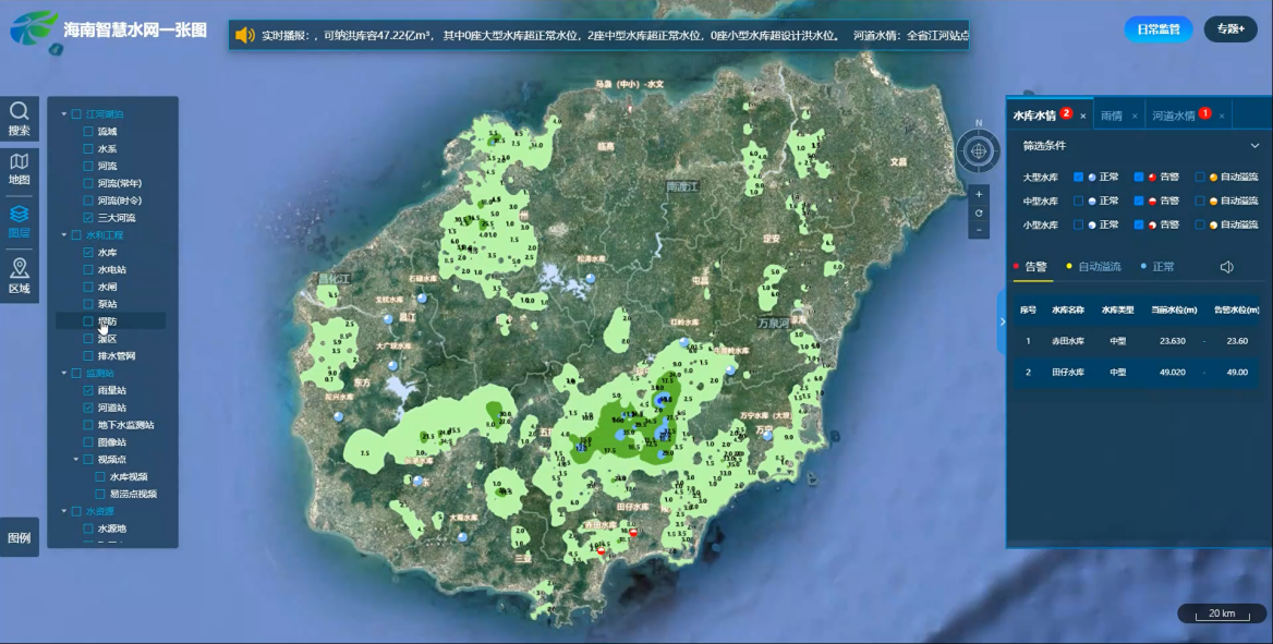
The construction of Hainan Smart Water Network in Hainan by IEIT SYSTEMS has comprehensively promoted the modernization of water management system and capabilities by creating a provincial integrated water network digital platform to gather water information in real time, control water resource intelligently, prevent and control water disaster, comprehensively protect water ecosystem, and provide water services for all.
 A Map of the Smart Water Network in Hainan Province
The Smart Water Networks has proven to be an invaluable tool in connecting service flows, data flows, and water flows. By using digital twins, data models, and mobile apps, the system has significantly and quantifiably improved supervision, management, and usage of water resources, providing digital support for extreme weather preparedness and disaster warning. For flood control in river basins, the system provides 80% of the rainfall status over the next hour throughout Hainan Province, with an accuracy of within 1 square kilometer, allowing proactive risk management by linking risk points and waterlogging points. Typhoon-related disasters can also be effectively monitored by loading multivariate data such as grid rainfall forecasts, typhoon paths, and risk points.
Water resources allocation is now managed digitally, gathering data on rivers, reservoirs, urban water use, and flood control scheduling, digitizing physical rivers, and building a big data platform for water affairs in Hainan Province. By analyzing precipitation within a 1 km grid range, the system uses data modeling and algorithm platform to predict the evolution of water yields and water resource allocation capability in rivers and reservoirs, and give intelligent scheduling choices. This regulation of water for production, living, agriculture and ecology has made Hainan Province’s social and economic development more dynamic than over before.
By the end of 2022, more than 3,000 basic water affairs staff in Hainan Province had used the “Smart Water Networks”. They have used Reservoir Manager to patrol the rivers and reservoirs over 218,200 times, covering over 100,000 kilometers. These inspections allowed them to discover 1,684 abnormal conditions and respond to over 90 million queries regarding flood and drought control.
IEIT SYSTEMS“End-Edge-Cloud-Big Data-AI” Assists in Smart Water Conservancy Construction
Visibility has always played a major role in the success of water conservancy. Traditional methods of water conservancy construction struggled with inadequate visibility, incomplete coverage of visual elements, and limited computing power within the information infrastructure. IEIT SYSTEMS offers vital technical support for building the smart water network in Hainan Province.
The network establishes a big data platform for water affair, creating a foundation for the “complete island map” and meeting the demand for intelligent water governance. A comprehensive, unified, and standardized water affairs information resource catalog was built by ensuring that every piece of data originates from an individual source and reorganizing existing water affairs data. In addition, a standard, complete, authoritative, and shared big data center for the water network has been built to achieve unified decision-making through a single map. This map serving Hainan Province was eventually formed by integrating resource data from mapping and imaging, vector, terrain, and 3D, using a map of Hainan Province.
 Dayu Pole with EIS200 edge intelligent computing server
Video monitoring and sensing devices, such as the Dayu Pole, were placed in critical positions around reservoirs and riverways all over Hainan Province to replace the traditional IoT devices. The devices’ AI technology act as the “Reservoir Manager”. Dayu Pole provides 24-hour real-time image data. The EIS200 edge intelligent computing server deployed on Dayu Pole and a high-precision AI recognition model are used to precisely analyze video streaming returned in real time, and give real-time warnings. For example, it can automatically read the data of important rivers, reservoirs, and water gages, identify floating objects on the water, intelligently identify, forecast, and issue warnings for zones where activities are prohibited, and distribute the data to relevant law enforcement officers through the “Smart Water Networks” app. All the while, the data cleaned on the edge is synchronized to the cloud center for tasks like AI recognition model training, optimization, data collection, and data mining.
Water governance and water management impact the livelihood and well-being of hundreds of millions of people. Creating a blueprint for “smart water governance” can improve the visibility, accuracy, comprehensiveness, and foresight, in water governance practices, making water management and maintenance more secure and enabling technological advancements in society. IEIT SYSTEMS computing power helps the Hainan build a smart water network that promotes more accurate information, more scientific decisions, and more convenient services. By fostering a healthier relation between humans and the water they consume, the smart water network paves the way for a happier Hainan Island. This collaboration represents a significant step toward advanced smart water management that improves ecological civilization and community of life for both people and nature.
![]()


